Showing posts with label geographer. Show all posts

Thursday, October 24, 2024

The Legacy of Pausanias: Preserving Ancient Greece

Pausanias, a Greek traveler and geographer, was born around 110 AD in Lydia, Asia Minor (modern-day Turkey). His work, Description of Greece (Ἑλλάδος Περιήγησις), is a detailed account of his travels through Greece, documenting its geography, monuments, and cultural practices. Living in the Roman Empire, Pausanias was deeply influenced by his Greek heritage, which shaped the focus of his writings. Despite Roman dominance, he emphasized the preservation of Greek history and culture. His work stands as a testament to the importance of maintaining historical identity in the face of foreign rule.

Pausanias traveled extensively, exploring regions like Asia Minor, Syria, Palestine, Egypt, and Italy before concentrating his efforts on Greece. His journeys gave him a broad perspective on Mediterranean cultures, but his heart remained tied to the rich cultural legacy of Greece. This is reflected in his accounts of Greek temples, sanctuaries, and statues, where he often intertwined physical descriptions with historical narratives and myths. Pausanias’s descriptions frequently include references to lesser-known sites, offering insights into regional variations in Greek culture that were often overlooked by other historians of the time.

Description of Greece holds immense value for historians and archaeologists today. Many of the ancient sites Pausanias documented have since been destroyed or altered, either by natural disasters, human intervention, or the passage of time. For instance, his detailed descriptions of temples and sacred places provide key information about their original structure, layout, and significance. His work also preserves an understanding of Greek religious practices, beliefs, and the myths that were vital to the local communities. By linking architectural descriptions with the associated myths and legends, Pausanias not only documented Greece's physical landscape but also its spiritual and cultural life.

Pausanias’s clear, factual writing style has made Description of Greece a reliable resource for the study of classical antiquity. His dedication to recording even minor details has ensured that his legacy lives on, making him an invaluable figure for anyone seeking to understand the complexities of ancient Greek civilization.
The Legacy of Pausanias: Preserving Ancient Greece

Saturday, January 21, 2023

Eratosthenes of Cyrene - Greek astronomer, geographer and mathematician

Eratosthenes (c. 276 BC – c. 195/194 BC), the ancient Greek scholar is called the ‘father of geography. He was the first one to use the word geography. He invented a system of longitude and latitude and made a map of the known world.

More than 2,000 years ago Eratosthenes compared the position of the Sun’s rays in two locations to calculate the spherical size of the Earth with reasonable accuracy.

He was a native of Cyrene, North Africa As a young man, he traveled to Athens to pursue his studies. His teachers included the scholar Lysanias of Cyrene and the philosopher Ariston of Chios who had studied under Zeno, the founder of the Stoic school of philosophy.

He returned to Cyrene and made such a name for himself in scholarly endeavors that the Greek ruler of Egypt brought him to Alexandria to tutor his son.

When the chief librarian of the famous Library of Alexandria died in 236 BCE, Eratosthenes was appointed to the prominent position around the age of 40. The library is said to have contained hundreds of thousands of papyrus and vellum scrolls.

Eratosthenes remained in Alexandria for the rest of his life, and it was there he made his calculations regarding the circumference of the earth and wrote his best-known works, including a three-volume set on geography credited with coining that term.

Eratosthenes tried to fix the dates of literary and political events since the siege of Troy. His writings included a poem inspired by astronomy, as well as works on the theatre and on ethics.

One of the important works of Eratosthenes was Platonicus which dealt with the mathematics which underlie Plato's philosophy. This work was heavily used by Theon of Smyrna when he wrote Expositio rerum mathematicarum.

Eratosthenes’ only surviving work is Catasterisms, a book about the constellations, which gives a description and story for each constellation, as well as a count of the number of stars contained in it.
Eratosthenes of Cyrene - Greek astronomer, geographer and mathematician

Monday, April 11, 2022

Pausanias – Greek traveler and geographer (110 – 180 AD)

Pausanias was a Greek author, historian, and geographer of the 2nd century AD. He journeyed extensively throughout Greece, chronicling these travels in his Periegesis Hellados or Description of Greece.

Pausanias was born approximately 110 AD into a Greek family in Magnesia ad Sipylum, a city in the province of Lydia, which was an Iron Age kingdom in what is now the western Turkish provinces of Izmir, Manisa and Usak. His youth was spent during the reign of the Roman emperor Hadrian (117 AD – 138 AD).

Pausanias well-educated and able to travel widely in Greece and beyond, including time to pursue his cultural interests, which implies that he must have enjoyed at least one important privilege: wealth.

Before visiting Greece, Pausanias had traveled widely in Asia Minor, Syria, Palestine, Egypt, Macedonia, Epirus (now in Greece and Albania), and parts of Italy. In Egypt, he had seen the pyramids. While at the temple of Ammon at Siwah, he had been shown the hymn once sent to that shrine by Pindar.

As a traveler, he used his firsthand observations to write a famous description of ancient Greece in a multi-book piece entitled Description of Greece which was written between the 150s and 170s AD. The Description is one of the most unusual works to survive from ancient literature, one of the most directly useful to Classical archaeologists active in mainland Greece - and one of the most fascinating for the discerning traveler.

In the ten volumes of the Description Pausanias refers frequently to the monuments and celebrations of Greek culture created by the Roman emperor Hadrian.

Pausanias' work has ended up influencing the development of classical archaeology to a larger degree than any other text. His many works are geared toward a Roman audience, since Romans wanted to know everything about the glories of Ancient Greece.
Pausanias – Greek traveler and geographer (110 – 180 AD)

Thursday, February 18, 2021

al-Muqaddasi (946 AD – 1000 AD)

Born at Al‐Bayt al‐Muqaddas (Jerusalem) in AD 946, al‐Muqaddasī (Shams ad‐Dīn Abū ˓Abdallāh Muḥammad ibn Aḥmad ibn Abī Bakr al‐Bannā), also called al‐Maqdisī, made important contributions in regional geography. He is considered the finest achievement in this field of medieval Islamic literature.

He is one of the most prominent representatives of Arabic geography in the second half of the 10th century AD. A traveler, geographer, and author, he is by far one of the most instructive of early Islamic social scientists.

In his early days he studied Muslim history, especially its political and cultural aspects, civilization, religion, and jurisprudence. To seek knowledge he visited distinguished scholars, met the men of science, and studied in royal libraries at a fairly young age.

Al-Muqaddasi was well-educated, and after having made the Pilgrimage to Mecca at age 20, he devoted himself to the study of geography.
Al-Muqaddasi attributes his motivation for travelling for twenty years from the Atlantic to the Indian Ocean, suffering hardships and writing about his travels, to divine inspiration: the accomplishment would be pleasing to his Lord, and would give life to his own memory.

Among other Arab geographers of the time, al‐Muqaddasī's definition of a region was probably the most original and produced one of the most valuable treatises in Arabic literature, Kitāb aḥsan‐al taqāsim fī ma˓rifat al‐aqālim (The Best Divisions for the Classification of Regions).

The book is an epic geographical treatise and also a great work of literature. This treatise was based on some twenty years of personal experiences and observations noted in his survey of the realm of Islam, from the Atlantic to the Indian Ocean.

Dividing the totality of the Islamic lands into a western, Arab half and an eastern, non-Arab half, he systematically analyzed the structure of each province and subprovince starting with the largest cities and working down through a hierarchy of subordinate towns and locales.
al-Muqaddasi (946 AD – 1000 AD)

Tuesday, October 10, 2017

Geographer Muhammad al-Idrisi

The greatest of the Muslim geographers was the Moroccan from Ceuta, Abu Abd Allah Muhammad Ibn Muhammad Al-Sharif al-Idrisi al-Qurtubi al-Hasani al-Sabti (1099–1165).

As a descendent of the Idrisid rulers of Morocco, who in turn were descendants of Hassan bin Ali the son of Ali, and the grandson of the Prophet Muhammad, this Muslim Arab scholar was tilted al-Sharif al-Idrisi, but in the West he was known from a long time as Geographus Nubiensis, the Nubian Geographer.

He studied at Cordoba, lived at Marrakesh for a while, and then traveled in North Africa during his youth. He may also have travelled some in Europe as well.

He did most of his work, however for the Norman King Roger of Siqilliyah (Scicily) at the capital of Balram (Palermo) after the island had been seized by the Norman Crusaders from the Muslims.

Al-Idrisi was a scientist, a geographer and a mapmaker. His geography is a synthesis of information and cartographic traditions from both Islamic and European cultures.

More than a mere traveller and accomplished geographer, Al-Idrisi founded the discipline of mathematical geography; he created the system of cylindrical projection of the earth’s surface, later in 1569 to be claimed as his own by Fleming, Gerard Mercator.

The most important book he produced is a world geography in 1154, Nuzhat al-mushtaq fi ikhtiraq al-afaq (Entertainment for One Desiring to Travel Far).

The book was created as a description of a large map, each chapter detailing itineraries within one of 70 sections illustrated by a regional map.

He later wrote a shorter geography, known under a variety of Arabic titles and usually referred to as ‘The Little Idrisi’.

Al-Idrisi’s scientific interests embraced medical matters as well geography. His Kitab al-adawiya al-mufradad (Book of Simple Drugs) lists the name of many drugs in an many as 12 languages.
Geographer Muhammad al-Idrisi

Friday, July 14, 2017

Hecataeus of Miletus

Hecataeus of Miletus (550 BC – 476 BC), a geographer and genealogist, wrote under the Persians. He was interested in Oriental genealogies and compared Greek with non Greek evidence

Hecataeus of Miletus, the son of Hegensander, the most important of the early Ionian prose writers, was active in the late 6th and early 5th centuries BC.
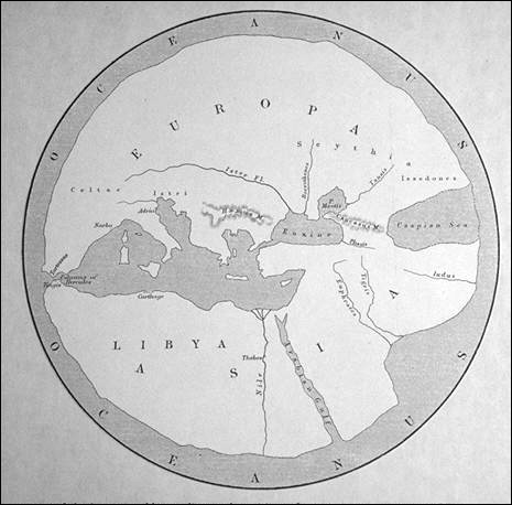
World according to Hecataeus
He was an Ionian Greek and a contemporary of Xenophanes who, like Xenophanes, wrote one of the first works critical of traditional Greek mythology. This was his Genealogies, in which Hecataeus tried to provide a rational account of myth and legend, including accout of his own supposed descent from a god.

He traveled in the Persian Empire as a Persian subject in its heyday. His successor Herodotus was born a Persian subject in the Greek city of Halicarnassus. He travelled in countries which were or had been Persian.

Apart from Genealogies Hecataeus also wrote a book that he titled Periegesis, journeys. The Periegesis was an account of the world, which Hecataeus divided into two continents, Europe and Asia. The Periegesis provides information about the places and peoples to be encountered on a clockwise coastal voyage round the Mediterranean and the Black Sea, starting at the Straits of Gibraltar and ending on the Atlantic –coast of Morocco. Hecataeus of Miletus

Monday, December 2, 2013

Who is Claudius Ptolemy?

Claudius Ptolemy was born around 100 AD., probably in Alexandria but possibly in Hermiou in Upper Egypt. He was a mathematician, astronomer and geographer.

Ptolemy lived during a stable period of internal tranquility and good government, and his main work appears to have been done during the reign of the Emperor Titus Antonius Pius, which lasted from 138 to 161 AD. 

Before his death in the late 170’s he had written a wide variety of works that included four major compendia: the Syntaxis Mathematike, the Geography, the Tetrabiblos and the Optics.

The Optics was probably written in the later years of his life. Translated into Arabic by the early tenth century at latest, this work has left no trace in either Greek or Arabic.

He presented his picture of the universe in his book Syntaxis Mathematike, in which he summed up ancient Greek thinking about the movements of the heavens. The book of Syntaxis Mathematike, is now almost universally known by the name ‘Almagest’ after the Arabic translation.

The earth according to Ptolemy was a sphere located at the centre of the universe.

The Almagest holds a prominent place in the history of mathematics and astronomy and was used as a primary resource for many hundreds of years.
Who is Claudius Ptolemy?

The most popular posts

Feed from FOOD SCIENCE AND HUMAN NUTRITION

Feed from History | Smithsonian

Feed from The Famous Painting

ANCIENT EMPIRE AND CIVILIZATION